IIT Bombay FOSSEE GIS Activities for Calendar Year 2025
The IIT Bombay FOSSEE GIS (NMEICT) project is excited to announce the activity array for the calendar year 2025. The GIS (Geospatial Information System) vertical of the FOSSEE project promotes the usage of Free/Libre Open Source GIS Software in Academia and Industry. All the activities of FOSSEE GIS are funded through, and conducted under the aegis of the National Mission on Education through ICT (NMEICT), Ministry of Education, Government of India.
Opportunity for everyone!
The main objective of IIT Bombay FOSSEE GIS is to spread awareness of Open Source-based Geospatial Software, promote Indian satellite data (ISRO - NRSC’s Bhuvan, Vedas, MOSDAC, Bhoonidhi Portals), and indigenous Indian technologies like NavIC (ISRO-SATNAV), etc. The FOSSEE GIS project, IIT Bombay (since 2020) has conceptualized and initiated dozens of nationally coveted, flagship activities which include but are not limited to, the IIT Bombay FOSSEE Geospatial Mapathon (the world’s biggest geospatial mapping challenge), National Geospatial Internship, National Geospatial Research Fellowship, National Geospatial Awards, domain-specific (medicine, agriculture, maritime) GIS Hackathons, National GIS Case Studies, etc, all of which aligns with the National Education Policy 2020 (NEP2020), the National Geospatial Policy 2022 (NGP2022), the Indian Space Policy 2023 (ISP2023). The niche open-source geospatial offerings by FOSSEE GIS, in Medical GIS (One Health), Artificial Intelligence, Green Energy and Sustainability (Electric Vehicle), Under Ocean Exploration, Waste to Wealth, and Rural Development are inspired by various interdisciplinary national missions and programs.
FOSSEE GIS (NMEICT) provides unrestricted access to institutions that have implemented NEP2020, with a plethora of opportunities with multiple entry/ exit options in the internship (for eligible candidates), open source geospatial curriculum design, faculty development, technically supporting in setting up an Open Source GIS lab, etc. All that the institution has to do is to subscribe itself and become FOSSEE’s Open Source Geospatial Knowledge Centre (OSGKC), more details are given below. The FOSSEE GIS project, IIT Bombay aims to create better opportunities for everyone (students, faculty, administrators, policymakers, etc) from diverse educational backgrounds interested in the field of geospatial science and technology.
FOSSEE GIS Mandates:
To participate in any of the FOSSEE GIS activities, the participating individual/team(s)/Institutions must follow the mandates as listed below:
- Indian Citizens Only.
- The participant(s) must be a bonafide student/faculty/staff of the institution recognized by UGC/AICTE/AIU or a body recognized by the Union and/or State Government.
- Use only Free/Libre Open Source Software/Open Source Hardware.
- Activity must align with at least one SDG (UNDP).
- Study area should be India-specific.
- Work on real-life data sets based on the Indian context.
- Datasets must be “non-sensitive” and from a “genuine/valid source”.
- Adhere to the (Indian) National Geospatial Policy 2022 and Indian Space Policy 2023.
- Use shapefiles from the Survey of India Portal ONLY.
- Use Indian satellite data from ISRO-NRSC’s MOSDAC, Bhuvan, Vedas, Bhoonidhi portals, and indigenous Indian technologies like NavIC, etc.
- Problem statements can be inclined toward the PM Gati Shakti Portal (recommended).
- The qualified entries of all IIT Bombay FOSSEE GIS (NMEICT) initiatives shall be released under the Creative Commons (CC-BY-SA or related) license.
Open Source GIS Day (September 15)
The “Open Source GIS Day” on September 15 has been initiated by the FOSSEE GIS team to celebrate the contribution made by the enablers, contributors, and practitioners (students, faculty, institutions, government organizations, industry professionals) of open source geospatial communities in India and across the world. To know more about the first Open Source GIS Day celebrations organized at IIT Bombay, click here https://www.iitb.ac.in/story/open-source-gis-day-national-geospatial-awards-2024-edition-01
To date, nearly 14 IITs, 15 NITs, 1000+ Affiliated/Autonomous Colleges, 200+ state affiliating Universities, and several Central Universities have participated in FOSSEE GIS activities since 2020. The core committee of the FOSSEE GIS project adopts the time-tested ‘Pyramid of Excellence Framework’ to scale up the reach of all of its initiatives, enabling a wider range of participation from students, faculty, administrators, policymakers, UGC/AICTE-recognized educational institutions, Government agencies, and partner organizations covering all the states and union territories across India. Calendar Year 2025 adopts the third upgraded version of the Pyramid of Excellence as shown below. It is envisioned and conceptualized at IIT Bombay by Mohamed Kasim Khan, National Coordinator, FOSSEE GIS (NMEICT), under the guidance of Prof. Kannan Moudgalya, Principal Investigator, FOSSEE, and Prof. Pennan Chinnasamy, Co.Principal Investigator, FOSSEE.
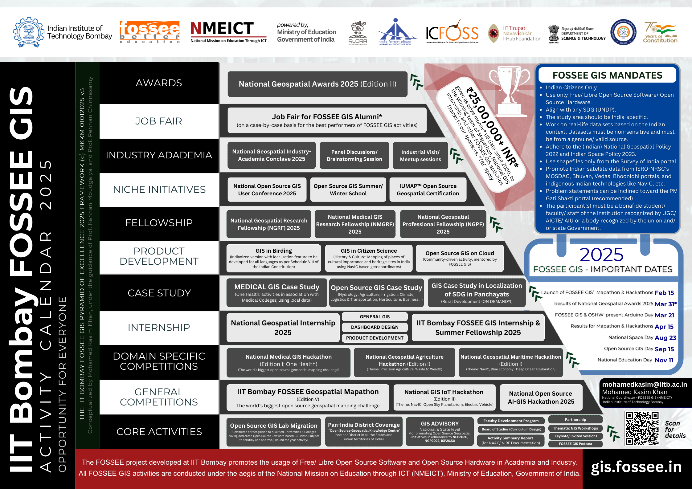
© The IIT Bombay FOSSEE GIS Pyramid of Excellence Framework (V3) MKKM 2025
Important dates:
|
|
|
|
|
|
|
|
|
|
|
|
|
|
|
|||
|
|
|
|||
|
|
|
|||
|
|
|
|||
|
|
|
|
|
|
|
|
|
|
|
|
|
|
|
|
|
|
|
|
|
|
|
|
|
|
|
|
|
|
|
|
|
|
|
|
|
|
|
|
|
|
|
|
|
|
|
|
|
|
|
|
|
|
|
|
|
|
||
Advisory and Partnerships:
The FOSSEE GIS team partners with select institutions of repute that share a similar vision for better adoption and outreach of Open Source Geospatial activities. The Rural Data Research and Analysis (RuDRA) Lab, IIT Bombay is the dedicated co-organizer and technical partner for all FOSSEE GIS activities. The Airports Authority of India (AAI) is a cherished co-organizer and prize sponsor. The FOSSEE GIS project promotes the usage of open source/publicly available data from Survey of India, National Remote Sensing Centre’s (NRSC) Bhuvan, Vedas, MOSDAC, and Bhoonidhi Portals, ISRO’s SATNAV PO (NavIC), and BIZAG-N and acknowledges them as ‘Resource Partners’. The IIT Tirupati Navavishkar I-Hub Foundation (funded by the National Mission on Interdisciplinary Cyber-Physical Systems (NM-ICPS), Department of Science and Technology (DST), Government of India), the International Center for Free and Open Source Software (ICFOSS- An autonomous body under the Department of Electronics and IT, Government of Kerala), Tamil Nadu Skills Development Corporation (Government of Tamil Nadu), Water Resource Department, Government of Maharashtra as co-organizer for select activities. The FOSSEE GIS team strategically works with OSGEO, and other international agencies to showcase the strength, India possesses in adopting and implementing Open Source Geospatial initiatives.
Open for Collaboration!
The FOSSEE GIS team is open to collaboration with Union/State Government Agencies, Universities, and Research Organizations, MNCs in India. Interested agencies can write to mohamedkasim@iitb.ac.in.
National and State-level Advisories are formed based on the recommendation of the core committee. UGC/AICTE/Central/State Government recognized Universities, Colleges, Research Organizations, Industry, Skill Development bodies, and MNCs specialized in the geospatial domain are welcome to nominate themselves. State-level advisory committees are also formed, on request. The key function of the advisory includes and is not limited to (i) devising a customized strategic plan for the State/UT, (ii) Defining the number of ‘internships’, ‘fellowships’, and ‘FDP’ with the possible support to be extended by the state agency. (iii) Collate the ‘problem statements’ from Government Departments, the District Collector Office, etc which require immediate GIS-based (thematic maps) solutions via FOSSEE GIS activities and alumni base, etc to start with.
Hindustan Times article on IIT Bombay FOSSEE GIS Activities (October 01, 2023): https://www.hindustantimes.com/cities/mumbai-news/how-amateur-mapmakers-are-solving-real-world-problems-101696138619348.html
The IIT Bombay FOSSEE GIS activity calendar adopts the Pyramid of Excellence model which can be scaled across all the states and union territories in India. There are eleven stages (bottom-up approach) in the pyramid for activities for the calendar year 2025.
1. Core/Foundational Activities
The FOSSEE GIS team conducts round-the-year initiatives which are grouped as ‘Core Activities”, that range from but are not limited to, the formation of National and State level advisories; organizing awareness sessions and thematic workshops for promoting Open Source Geospatial software/tools at UGC/AICTE/AIU recognized institutions in every district of all the states and union territories of India; Forging partnership with key government agencies and organizations, etc.
1.1. Open Source GIS Lab Migration
The “Lab Migration” initiative aims to migrate an existing GIS & Remote Sensing Lab into a Free/Libre Open Source Software only lab. “Certificate of Recognition” shall be issued to qualified Universities & Colleges having dedicated Open Source Software GIS labs. For more details, write to mohamedkasim@iitb.ac.in
1.2. Pan-India District Coverage (National Outreach)
This initiative aims to cover every district in India spanning all states and union territories, to ensure the FOSSEE GIS (NMEICT) project benefits (internship, FDP, joint research, etc) reach the deserving faculty, scholars, and students in UGC/AICTE and/or government recognized institutions/organizations.
Interested institutions (UGC/AICTE/Central/State Government recognized Universities, Colleges, Research Organizations, Industry, Skill Development bodies, etc), are requested to email a ‘letter of intent’.
Out of the registered institutions, there will be one institution identified per district, certified as “an “Open Source FOSSEE Geospatial Knowledge Centre (OSFGKC)” based on their national ranking (NIRF or NAAC score) and/or contribution to FOSSEE GIS activities till date. The final decision of the OSFGKC will rest with the FOSSEE GIS project.
Note:
- The institution chosen to become OSFGKC shall get an “e-Certificate of recognition” which shall be valid for a stipulated period as decided by the FOSSEE GIS team.
- Every qualified registration (institute) shall be given a dedicated ID number.
- Institutions formally registered with FOSSEE GIS shall ONLY be considered for the “Best University/Best College" award in the "National Geospatial Awards 2025 (Edition II)".
- An “Activity Summary Report (ASR)” shall be given, on request, to the subscribed/registered institutions for their NAAC/NIRF documentation needs. To obtain an ‘ASR’, the subscribed/registered institution must provide (i) An NOC, (ii) the Institution’s Activity Calendar in line with FOSSEE GIS’s initiatives in 2025, and (iii) a Letter of Intent (LOI), all duly endorsed and attested by the Head of the Institution.
For more details, please write to mohamedkasim@iitb.ac.in.
1.3. Open Source GIS Day
The Open Source GIS Day is an initiative of the FOSSEE GIS project, IIT Bombay to celebrate the contribution made by the enablers, contributors, and practitioners (students, faculty, institutions, government organizations, industry professionals) of open source geospatial communities in India and across the world. The Open Source GIS Day is perceived to be an annual event. It started on 15 September 2024. It shall showcase key developments and achievements accomplished by various stakeholders of Open Source-based Geospatial communities. As a part of this year’s Open Source GIS Day celebrations, the FOSSEE project plans to conduct invited/expert talks, keynote sessions, panel discussions, etc.
|
|
|
OSFGKCs are welcome to host local “Open Source GIS Day” by inviting nearby institutions. An “e-certificate” will be given to all OSFGKCs or Institute(s) that conduct the activity, and furnishes a valid report.
For more details, please write to mohamedkasim@iitb.ac.in.
1.4. Arduino Day 2025 - a celebration by FOSSEE GIS & Open Source Hardware (OSHW) team
Arduino Days is a worldwide celebration of Arduino’s birthday, bringing people together to share their experiences and learn more about the open-source platform. In addition to the official Arduino event, which will be streamed live, the FOSSEE project, IIT Bombay team will conduct parallel sessions on campus. All user groups including hackerspaces, fablabs, associations, teachers, schools, professionals, start-ups, and newbies are welcome to join the event online. e-Certificate of participation shall be given to every institute*.
A unique opportunity shall be given to the #Schools #Colleges in Maharashtra (and neighbouring states) to witness the program in person during the #ArduinoDay2025 celebrations organized at IIT Bombay.
|
|
|
To confirm your institution’s participation, please write to rajesh@cse.iitb.ac.in and mohamedkasim@iitb.ac.in.
Limited seats! RSVP is Mandatory!
1.5. National Space Day (India)
Celebrations by the FOSSEE GIS team at IIT Bombay on August 23, 2025 [Hybrid Mode]
India will be celebrating its second National Space Day [NSpD-2025] on August 23, 2025. The FOSSEE GIS project, IIT Bombay under the aegis of the National Mission on Education through ICT (NMEICT), Ministry of Education, Government of India will be showcasing its unique initiatives which promote the use of Indian satellite data, in adherence to the National Geospatial Policy (2022), and the Indian Space Policy 2023, thereby increasing (UGC/AICTE recognized) institutional participation across India.
The Vice-Chancellors/Directors/Principals of the Educational Institutions who would like to join the "National Space Day celebrations by FOSSEE GIS (NMEICT)" in-person/or online mode are requested to send an email to mohamedkasim@iitb.ac.in.
Participating institutions (with valid/accepted registrations) shall receive an “e-certificate of participation” from the FOSSEE GIS project team.
|
|
|
Note: * Certificates will be in digital format and will be issued to Institutions once they upload a photo proof (with geo-tag) + a short report + tagging FOSSEE on social media, post-event.
1.6. National Education Day
The FOSSEE project, IIT Bombay invites everyone to join the National Education Day Celebration commemorating the birth anniversary of Maulana Abul Kalam Azad, India’s first Education Minister, on November 11, 2025. During this event, the FOSSEE team shall showcase its key initiatives, along with invited talks, panel discussions, etc. For more details, write to mohamedkasim@iitb.ac.in.
|
|
|
1.7. Open Source GIS-themed Conferences, Workshops & Faculty Development Program
The FOSSEE GIS team intends to organize/co-organize (i) National Open Source Geospatial Software End-user Conferences (ii) Endorse Open Source Geospatial Workshops organized region-wise (proposal must be submitted beforehand for approval), and (iii) 100 Faculty Development Programs this year (2025) on Open Source Geospatial Technologies in association with Institutions across India.
Note:
- Approvals for endorsements shall be given after scrutiny of the proposal(s).
- This is a round-the-year activity.
- FDPs can range between 01 to 12 days max.
- The IIT Bombay FOSSEE GIS team shall depute the resource person, on request.
Detailed announcements about the “National Open Source Geospatial Software End User Conference 2025” shall be published on the official website.
Interested Universities and Colleges can write to mohamedkasim@iitb.ac.in for more details.
1.8. Board of Studies (Curriculum Design)
The FOSSEE GIS team offers top-class Open Source Geospatial curriculum design support to interested Universities and Colleges in India. Institutions implementing the National Education Policy 2020 (NEP2020) shall be given preference, including a defined quota for internships (subject to the presence of a qualified local mentor), national geospatial fellowship (pro bono), case studies, etc. There is also a “Best Geospatial Curriculum” category in the National Geospatial Awards 2025 (Edition 01). For more details, write to mohamedkasim@iitb.ac.in
1.9. Invited/Keynote sessions & FOSSEE GIS podcasts
Professional bodies, Institutions, and Policymakers can invite the FOSSEE GIS team to deliver the Keynote/Invited sessions during their national/state-level summit, conclave, conferences, symposiums, workshops, etc. The core team of FOSSEE GIS 2025 will be scheduling dedicated podcast sessions on various topics, featuring distinguished experts in the field of geospatial science and technology. Kindly write to mohamedkasim@iitb.ac.in for any queries.
2. Flagship Competitions
The FOSSEE GIS project, IIT Bombay is the main organizer of some of India’s most coveted national competitions in the field of geospatial science and technology.
The Champions and Winners of such competitions directly participate in IIT Bombay FOSSEE GIS Summer Fellowship and Internship 2025 (Edition II), and are eligible to directly apply for the i. National Geospatial Internship 2025 (General GIS, Product Development, Dashboard design); ii. National Geospatial Research
Fellowship (FOSSEE GIS mentored), and iii. National GIS Case Study (for real-life India-specific problem statements that can be solved using thematic maps).
2.1. IIT Bombay FOSSEE Geospatial Mapathon 2025 (Edition V)
The IIT Bombay FOSSEE Geospatial Mapathon 2025 (Edition V) is the world’s biggest open-source-based geospatial mapping challenge. Mapathon is a map-making competition for creating thematic maps, using open-source data and mapping software. It is a collaborative event where participants come together to develop new tools/methods that improve the accuracy and usefulness of maps for a community. The FOSSEE team at IIT Bombay, along with its partners the Rural Data Research and Analysis (RuDRA) Lab, IIT Bombay, and IIT Tirupati Navavishkar I-Hub Foundation (NM-ICPS, DST, Government of India, ICFOSS, TNSDC, WRD - Government of Maharashtra, will invite all Indians - to produce maps using various data (e.g. observation data, remote sensing data, crowdsourced data, etc.). The primary objective is to understand the potential of remote sensing data and make maps for Indian regions using free open-source mapping software (e.g. QGIS). The participants will collectively work in a crowd-sourcing method for jointly producing thematic maps of India. The data collected from various platforms have tremendous potential in mapping India’s resources, agriculture, climate, disaster management, rural and urban planning, and identifying pathways for future development. Such maps can be created using Free Open Source platforms (such as QGIS). Let us join together to create such maps through the Mapathon. The FOSSEE GIS project, along with its partner organizations has successfully organized four editions of Geospatial Mapathon (Edition 01 IITB-ISRO-AICTE (2020-2021); Edition 02 IITB-AICTE-GISE-GRSS (2022); Edition IITB-IITTNiF-TNSDC (2023); Edition 04 IITB-IITTNiF-ICFOSS-TNSDC (2024).
The fifth edition of IIT Bombay FOSSEE-AAI Geospatial Mapathon 2025 shall commence on March 01, 2025. The Rural Data Research and Analysis (RuDRA), Lab, Airports Authority of India (AAI), International Centre for Free and Open Source Software (ICFOSS), WRD-Government of Maharashtra, Tamil Nadu Skill Development Corporation are the organizing partners. For any queries, write to mohamedkasim@iitb.ac.in.
IIT Bombay FOSSEE-AAI Geospatial Mapathon 2025 (Edition V): https://gis.fossee.in/mapathon
2.2. National GIS IoT Hackathon (Edition II)
The National GIS-IoT hackathon is more than just a competition; it's a platform for innovators, creators, and visionaries to come together and pioneer solutions for a brighter future. The purpose of this hackathon is to harness the power of Open Source Hardware, the Internet of Things (IoT), and Geographic Information Systems (GIS) to address some of India’s most pressing challenges. For any queries, please write to rajesh@cse.iitb.ac.in and mohamedkasim@iitb.ac.in.
National GIS IoT Hackathon (Edition II) URL: https://iot-gis-hackathon-2025.fossee.in
2.3. National Open Source AI-GIS Hackathon 2025
This hackathon has been envisioned to provide a platform for enthusiasts to create Open Source AI-based geospatial maps in the Indian context using publicly available non-sensitive datasets for solving societal problems all in adherence to the Indian Space Policy 2023, and the National Geospatial Policy 2022. For partnership queries, write to mohamedkasim@iitb.ac.in.
URL: https://aigis-hackathon.fossee.in
3. Domain-Specific Competitions
FOSSEE GIS, IIT Bombay promotes the use of open-source geospatial software in fields like Agriculture, Medicine, Maritime studies, etc. Similar to flagship competitions, the domain-specific has received acclaim from policymakers, industry experts, and domain experts. The datasets used must be from genuine sources with proper permission obtained from the data providers/ government agencies. Use of sensitive information is not allowed. Every domain-specific FOSSEE GIS competition has a dedicated industry/ academic partner associated as a co-organizer. The final report(s) (including maps) of the qualified team(s) shall be released under the Creative Commons license.
3.1. National Medical GIS Hackathon (Edition 01 - Theme: One Health)
The primary objective of the National Medical GIS Hackathon is to understand and manage healthcare challenges through location-based data. By using GIS, participants can develop solutions that improve disease surveillance, track outbreak milestones, and support mass gatherings and public health events. These solutions are critical for effective participatory surveillance, where both healthcare and technology experts collaborate to create real-time systems for monitoring and responding to health issues. This event will highlight the population-scale programs, digital transformation, and climate change, all of which are increasingly impacted by geographical factors. The Participants work together to create GIS-based digital tools, apps, or systems that can enhance healthcare delivery, from better tracking of diseases to more efficient use of medical resources. The event focuses on solving real-world problems such as disease surveillance, outbreak management, mass gatherings, and healthcare data analysis. Participants will work on creating digital solutions for health data management and crisis response, with an emphasis on One Health initiatives and supporting digital transformation in healthcare. By applying the One Health approach and utilizing GIS, the hackathon aims to develop innovative solutions that address global health challenges, enhance crisis response, and improve data-driven decision-making across human, environmental, and animal health sectors. The goal is to create scalable, technology-driven solutions that can have a direct impact on patient care, public health, and the broader healthcare system. The co-organizer for the National Medical GIS Hackathon is the Honeybee Population Healthcare Foundation (HPHF). The Rural Data Research and Analysis (RuDRA) lab is the technical partner; ICFOSS, IITTNiF, ICMR-NIE, ICMR-NIRT, and RailTel are the knowledge partners. For partnership queries, write to mohamedkasim@iitb.ac.in.
National Medical GIS Hackathon URL: https://medicalgis.fossee.in
3.2. National Geospatial Agriculture Hackathon (Edition 01- Theme: Precision Agriculture & Waste Management)
The National Geospatial Agriculture Hackathon (Edition 01) aims to identify solutions for problems in the field of agriculture. The focused theme of this year’s hackathon will be ‘precision agriculture’. This activity will be primarily open for the students and faculty of Agricultural Universities and Colleges in India, and related disciplines. Sher-e-Kashmir University of Agricultural Science and Technology of Kashmir, Srinagar is the co-organizer for edition 01. For partnership queries, write to mohamedkasim@iitb.ac.in.
National Geospatial Agriculture Hackathon URL: https://agrogis.fossee.in/
3.3 National Geospatial Maritime Hackathon (Edition 01)
A focused open-source geospatial hackathon dedicated to the stakeholders belonging to the ‘Maritime studies’ and related domains. NavIC (Indian GNSS) and Under Ocean Exploration are the focus themes for the first edition. Institutions in India offering courses in Maritime studies, Marine Engineering, Ocean Technology, and related disciplines can write to mohamedkasim@iitb.ac.in for partnership queries. India’s first maritime university, the Academy for Maritime Engineering and Training (AMET Deemed-to-be-University) is the co-organizer and prize sponsor. For partnership queries, write to mohamedkasim@iitb.ac.in.
National Geospatial Maritime Hackathon (Edition 01) URL: https://maritimegis.fossee.in.
4. Coveted Internships
The Internships offered by the FOSSEE GIS project, IIT Bombay are highly contested and counted among the top avenues in India and are classified into two broad categories.
4.1. National Geospatial Internship 2025
National Geospatial Internship 2025 is open for UG, PG, PhD students of any background interested in interdisciplinary geospatial topics. Candidates for the National Geospatial Internship 2025 (#NGI2025) are selected through a direct application process based on the strength of their a. Research Proposal; b. Statement of Purpose; c. Resume/ CV; d. NOC from the head of the institute. Current UG/ PG final-year students doing their project work in the (interdisciplinary) geospatial domain can apply. A total of one thousand eligible candidates, if identified shall get a chance. This is a ‘pro bono’ remote internship. Applicants can have a local faculty from their institute/ College as a mentor along with a mandatory mentor from FOSSEE GIS, IIT Bombay. Detailed information shall be made available on https://gis.fossee.in.
FOSSEE’s OSGKC (Open Source Geospatial Knowledge Centre) will be eligible to nominate one candidate directly for the National Geospatial Internship, subject to the scrutiny of their profile, proposal, methodology, etc as required. For any queries, write to mohamedkasim@iitb.ac.in.
The candidates selected for the National Geospatial internship shall be classified into the following groups, depending on the nature of their work.
4.1.1. General GIS
This group of interns shall be working on a problem statement aimed at purely creating a thematic map as a solution for their problem statement. The complexity of the problem statement, methodology used, quality, and source of datasets shall play a crucial role during the evaluation process.
4.1.2. Dashboard Design
Applicants interested in creating geospatial dashboards shall be placed in this group. The end output will be a fully functional dashboard for the proposed idea.
4.1.3. Product Development
Candidates having open source technical skills and knowledge in (geospatial) product development shall be assigned under this group.
|
|
|
4.2. IIT Bombay FOSSEE Geospatial Internship and Summer Fellowship 2025 (Edition II)
The IIT Bombay FOSSEE GIS Summer Fellowship and Internship 2025 (Edition II) is a flagship activity of the FOSSEE-GIS team, which will be conducted in two stages i.e. Stage 1: Summer Fellowship (First month); Stage 2: Maim Internship (02 to 06 months). Candidates will be chosen based on three categories.. (i). Champions, Winners, and notable participants of IIT Bombay FOSSEE Geospatial Mapathon 2024 (Edition IV) & IIT Bombay FOSSEE-AAI Geospatial Mapathon 2025 (Edition V); (ii). Open Registration; and (iii). Special Purpose Vehicle (a special drive to get on board bright students from the North-Eastern States, Jammu and Kashmir, Andaman and Nicobar Islands, Lakshadweep, etc). Candidates will be selected based on the strength of their S.o.P. (Statement of Purpose), and a screening task which will determine their ability to work using GIS-based Free/Libre Open Source Software/ tools.
The IIT Bombay FOSSEE GIS Summer Fellowship and Internship is considered to be one of India’s most coveted internships in the Geospatial domain with over 3000+ unique applications received from students studying in various Universities/ Colleges across India. More details will be published on https://fossee.in website. For related queries, write to mohamedkasim@iitb.ac.in.
Note:
- District Collectors/ Administrations, and Government Ministries can send us their problem statement which will be assigned to the interns, who will try to solve the problems under the mentorship of the IIT Bombay-FOSSEE-GIS team and from partner institutions.
- Students who have already been offered or have participated in any form of Summer Fellowship/ Internship conducted by the IIT Bombay FOSSEE GIs team will not be eligible to apply.
- Incomplete work or non-compliance to any of the FOSSEE GIS mandates by the selected candidates shall result in disqualification from the internship.
- The duration of the internship shall be decided by the IIT Bombay FOSSEE GIS team.
- The internships are pro bono and remote.
5. Open Source GIS Case Study
Applications are invited from the Vice ChancellorsDeans/Directors/Principals/HODs of reputed (top 100 NIRF shall be given preference) Institutions in India offering courses in areas of Hydrology, Disaster Management, Waste Management, Green energy and sustainability, Soil conservation, Wildlife, Geography, Geology, Geoinformatics, Remote Sensing, Rural Development, Urban Studies, Policy, Engineering or any GIS-based interdisciplinary domain. The selected team(s)/institutions will win a chance to work closely with the IIT Bombay Faculty and the experts from the IIT Bombay FOSSEE GIS team. Best proposals will also get to participate as co-authors in impactful research work carried out in the GIS domain by the IIT Bombay FOSSEE GIS team.
5.1. National GIS Case Study (Hydrology, Agriculture, Irrigation, etc)
The National GIS Case Study is a research-intensive activity based on any of the common societal problems that could be resolved using Open Source Geospatial tools. This is a round-the-year activity. Eligible institutions can apply till May 10, 2025. For related queries, write to mohamedkasim@iitb.ac.in.
5.2. Medical GIS Case Study (One Health)
The application window is now open for established MEDICAL COLLEGES & RESEARCH CENTRES in INDIA that have a strong Community Medicine Department with a Data Center facility. For more details, write to mohamedkasim@iitb.ac.in.
5.3. GIS Case Study in Localization of SDG (Rural Development (ON DEMAND))
The GIS Case Study in localization of SDGs in the Panchayati Raj Institutions will be based on the RDO framework developed at the Rural Data Research and Analysis (RuDRA) Lab, IIT Bombay. The application window for this activity will open in the first week of January 2024. For more details, write to mohamedkasim@iitb.ac.in
6. Open Source GIS Product Development
This is a niche activity of the FOSSEE GIS team aimed at developing open source-based geospatial products (solutions) as a community-driven effort. The process involves forming a national-level advisory, and conducting brainstorming sessions, and periodical reviews.
6.1. GIS in Birding
GIS in Birding is an activity envisioned to create an India-specific tool to track the species of birds and their migration in India. It shall feature a complete open source-based environment, shape files from Survey of India, NavIC-compatible (GNSS) location indicators, the option to annotate in Indian languages, etc. This shall be a community-driven activity. Interested institutions and individuals willing to contribute to this fully open-source-based effort can write to us for more details.
GIS in birding point of contact: ushav372@iitb.ac.in and mohamedkasim@iitb.ac.in
6.2. GIS in Citizen Science
Mapping of culturally significant places in India in association with the IndianCulture.gov.in project using NavIC coordinates and developing an app with a featured India map with shapefiles from Survey of India. OSGKCs shall be allowed to jointly contribute to this effort.
6.3. Open Source GIS on Cloud
The “GIS on Cloud” is a Open Source Software community-driven product development activity initiated by the IIT Bombay FOSSEE-GIS team. This will be a unique opportunity for students having Remote Sensing. GIS, Geology, Geography, Geoinformatics, Environmental Science, Hydrology, Civil Engineering, Architecture, Urban planning, Rural Development, Policy, and Computer science with Open Source Software coding background to participate in this activity of national importance as an Intern, under the mentorship of eminent faculty from IIT Bombay, the FOSSEE(GIS) team, and partner institutions. For more details, please write to mohamedkasim@iitb.ac.in.
7. Fellowships
The FOSSEE GIS project, IIT Bombay offers research-focused national fellowships to deserving PG students, and Ph.D. scholars from UGC/AICTE-recognized institutions across India. This is a pro bono activity aimed at offering a value addition to institutions implementing the National Education Policy 2020 (NEP2020).
7.1. National Geospatial Research Fellowship (NGRF) 2025
The National Geospatial Research Fellowship 2024 (Batch 01) is aimed at providing an enriching experience for the young minds of India who want to excel in open-source GIS research, in alignment with the National Geospatial Policy 2022, and the India Space Policy 2023. NGRF shall serve as a platform to work on an India-specific problem statement mentored/ jointly mentored by the FOSSEE GIS which shall shape into a unique publication of good quality. This endeavor shall offer a chance for the fellows to exhibit their academic intellect and even motivate them to apply to reputed Universities in India, and across the world. For related queries, write to mohamedkasim@iitb.ac.in.
7.2. National Medical GIS Research Fellowship (NMGRF) 2025
The NMGRF is aimed at providing a unique opportunity for practitioners in the Medical GIS domain. The fellowship will focus on problem statements on the One Health theme. This activity shall be co-organized jointly by IIT Bombay FOSSEE GIS, the Rural Data Research and Analysis (RuDRA) Lab, IIT Bombay, and Honeybee Population Healthcare Foundation (HPHF).
|
|
|
8. Stage 8: Niche Activities
8.1. National Open Source GIS User Conference 2025
A national-level conference organized by the FOSSEE GIS team in association with its partners and Industries in the Geospatial field. The Annual FOSSEE Geospatial Conference will be conducted at IIT Bombay. For partnership and sponsorship queries, write to mohamedkasim@iitb.ac.in.
8.2. Open Source GIS Summer/Winter School
The IIT Bombay FOSSEE GIS team along with its partners plans to conduct a dedicated GIS Summer School as a premium offering for the students currently studying in Colleges across India. More details will be published before the registration start date on gis.fossee.in. Limited seats! The FOSSEE GIS subscribed Colleges/ Open source Geospatial Knowledge Centres (OSGKC) will have early bird access to the registration portal.
8.3. IUMAP ™ Open Source Geospatial Certification
International Union of Mappers for Atlas and Planning is a trademarked initiative of the Rural Data Research and Analysis (RuDRA) Lab, IIT Bombay. The certification program which will be jointly conducted by IIT Bombay-FOSSEE-GIS and the RuDRA Lab will be mainly focused on GIS and Remote Sensing using Open Source Software. The process of the IUMAP™ certification program is being finalized. Detailed information will be made available on www.rudra.iitb.ac.in and https://gis.fossee.in.
9. Industry-Academia Connect
The National Level Geospatial Academia-Industry Connect is planned to be conducted in May 2025. This will be an Open Source GIS community-driven activity with the subscribed partner Institutions of the FOSSEE GIS project playing a vital role in the organizational part. Government agencies, Policy Makers, Companies/Industries, professionals, etc in the GIS sector will be invited. This event will feature keynote sessions, panel discussions, parallel presentation sessions, and more.
Entities willing to partner with us on this conclave can write to us at <mohamedkasim@iitb.ac.in> for more information.
10. Job Fair
A dedicated Job Fair in the Geospatial domain for the alumni (Mapathon, Hackathon... Champions, Winners & Interns) of the FOSSEE GIS project and for the students of FOSSEE GIS subscribed Institutions. Companies looking for potential candidates for the GIS-based vacancies can write to us to participate in this job fair as a recruiter. For more information, please write to mohamedkasim@iitb.ac.in.
11. National Geospatial Awards 2025 (Edition II)
Celebrating India's contribution in the domain of Geospatial Science and Technology. The National Geospatial Awards 2025 (Edition 02) is an initiative of the FOSSEE (GIS) project, lIT Bombay under the aegis of the National Mission on Education through ICT (NMEICT), Ministry of Education, Government of India. The key objectives of the 'National Geospatial Awards 2024 are to honor the enablers and users of Geospatial Technology in India, cutting across professions (Institutions, Faculty, Industry professionals, Individuals, etc), along with celebrating the spirit of Open Source Geospatial/GIS tools which has empowered stakeholders and policymakers to adopt the latest technologies that align with the National Geospatial Policy 2022', and the 'Indian Space Policy 2023'.
To know more about the National Geospatial Awards 2024 (Edition 01), please visit: https://www.iitb.ac.in/event/national-geospatial-awards-2024-edition-01
URL: https://fossee.in/gis/awards
|
|
|
|
|
|
The FOSSEE GIS team is part of the FOSSEE project (since 2009), developed at IIT Bombay which is funded through the National Mission on Education through ICT (NMEICT), Ministry of Education, Government of India. The FOSSEE project is headed by Prof. Kannan Moudgalya (Principal Investigator); Prof. Pennan Chinnasamy (Co.P.I.) leads the GIS vertical of the project; Mohamed Kasim Khan M (National Coordinator - FOSSEE GIS & Senior Project Research Scientist) coordinates the overall conceptualizing, strategic planning, partnership, and implementation of all the IIT Bombay FOSSEE GIS activities. Public sector agencies, Skill Development bodies, and Educational institutions (UGC/AICTE/AIU recognized Universities, Colleges, etc), Industries specialized in the GIS domain seeking collaboration can write to <mohamedkasim@iitb.ac.in>, and help us spread awareness on the IIT Bombay FOSSEE GIS team’s national level initiatives for the benefit of teaching fraternity, industry professionals, student community present at large.
URL: https://gis.fossee.in/schedule/2025
Email: mohamedkasim@iitb.ac.in; info@fossee.in
Phone: (022) 2567 4111
Venue: IIT Bombay (hybrid mode)
#IITBombay #FOSSEE #GIS #FOSSEEGIS #NMEICT #OpenSource #ISRO #NEP2020 #NGP2022 #ISP2023 #Bhuvan #MOSDAC #Bhoonidhi #VEDAS #NavIC #SATNAV #AAI #Data #Mapathon #Internship #Fellowship #MedicalGIS #Maritime #Agriculture #Water #Climate #RuralDevelopment #Urban #Policy #NRSC #NESAC #KannanMoudgalya #PennanChinnasamy #MohamedKasimKhan #OEGEO #OSGIS #Academia #Research #Industry #GovernmentOfIndia #MinistryOfEducation